Supersize UK Counties Map (Laminated Wall Map)
Prices from
COMPARE ALL WEBSHOPS
(1)
Amazon
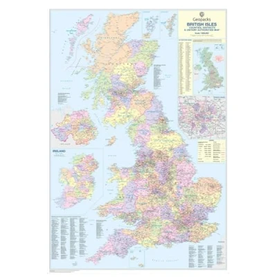
✅ Full UK Coverage – Displays all County, District, and Unitary Authority boundaries in distinct colors for easy identification. ✅ Major Roads & Towns – Includes motorways, primary roads, and detailed road networks (with a special London inset for clarity). ✅ Ireland & London Maps – Includes an inset of Ireland’s County boundaries and a detailed London Borough map. ✅ Latest Population Data – Provides accurate regional population figures, sourced from the Local Government Commission (as of 2010). 📏 Size: 120 x 174 cm (47 x 68 inches) 📍 Scale: 1:440,000 (7 miles per inch)
Read more
99.99
Featured

|
£ 99.99 |
To Shop
|
 Description
Amazon
✅ Full UK Coverage – Displays all County, District, and Unitary Authority boundaries in distinct colors for easy identification. ✅ Major Roads & Towns – Includes motorways, primary roads, and detailed road networks (with a special London inset for clarity). ✅ Ireland & London Maps – Includes an inset of Ireland’s County boundaries and a detailed London Borough map. ✅ Latest Population Data – Provides accurate regional population figures, sourced from the Local Government Commission (as of 2010). 📏 Size: 120 x 174 cm (47 x 68 inches) 📍 Scale: 1:440,000 (7 miles per inch)


Compare webshops (1)
Shop

Price
✅ Full UK Coverage – Displays all County, District, and Unitary Authority boundaries in distinct colors for easy identification. ✅ Major Roads & Towns – Includes motorways, primary roads, and detailed road networks (with a special London inset for clarity). ✅ Ireland & London Maps – Includes an inset of Ireland’s County boundaries and a detailed London Borough map. ✅ Latest Population Data – Provides accurate regional population figures, sourced from the Local Government Commission (as of 2010). 📏 Size: 120 x 174 cm (47 x 68 inches) 📍 Scale: 1:440,000 (7 miles per inch)
 Product specifications
 Related products
Featured Choice
£ 99.99


