


£ 16.79

Sponsored links
|
|
£ 16.79 |
To Shop
|
| COMPARE ALL WEBSHOPS (1) | ||
 Description
Compare webshops (1)
Sponsored links · Some shops pay us a fee
£ 16.79
Shops with other sizes
Description
(1)
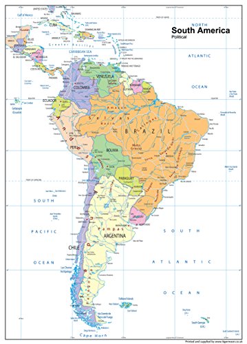
South America, a continent located entirely in the Western Hemisphere, is predominantly situated in the Southern Hemisphere, with a smaller portion in the Northern Hemisphere. It is known as the southern subregion of the Americas, bordered by the Pacific Ocean to the west and the Atlantic Ocean to the north and east. To the northwest, it is neighbored by North America and the Caribbean Sea. South America is home to twelve sovereign states: Argentina, Bolivia, Brazil, Chile, Colombia, Ecuador, Guyana, Paraguay, Peru, Suriname, Uruguay, and Venezuela; two dependent territories: the Falkland Islands and South Georgia and the South Sandwich Islands; and one internal territory: French Guiana. Our Political Map of South America is vibrant and informative, with easy-to-read text and bright colours. Including capital cities, rivers, major roadways, towns and surrounding bodies of water. The political aspects such as state and national boundaries and capital and major cities are included and makes for an attractive map either for the home, office or school, for display on a wall or for desk work. Size A1 - 59.4 x 84.1 cm. Printed onto high quality poster paper and laminated for durability.
 Related results
 Product specifications


