South Wales Postcode Sector Map 11 Laminated Wall
Featured

|
£ 12.99 |
To Shop
|
 Description
Amazon
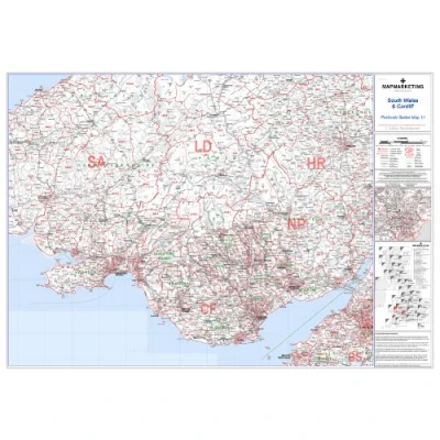
Sector Sheet 11 covers a detailed area of South Wales, stretching from Leominster in the north to Barry in the south, and from Bristol in the east to Cwm-Morgan in the west. With dimensions of 73 x 107 cm (29 x 42 inches), this map offers ample space for clear and precise navigation. The scale of 1:150,000 (2.4 miles to 1 inch) ensures that even intricate details are discernible, facilitating accurate planning and exploration. Updated with the latest information from the Royal Mail Postcode Update R54 (March 2012), the map incorporates all recent postcode changes, ensuring relevance and accuracy. Featuring distinct color coding, area, district, and sector boundaries are highlighted in red, while county and unitary authority boundaries are delineated in green, providing a comprehensive understanding of the region's administrative divisions.


Compare webshops (1)
Sector Sheet 11 covers a detailed area of South Wales, stretching from Leominster in the north to Barry in the south, and from Bristol in the east to Cwm-Morgan in the west. With dimensions of 73 x 107 cm (29 x 42 inches), this map offers ample space for clear and precise navigation. The scale of 1:150,000 (2.4 miles to 1 inch) ensures that even intricate details are discernible, facilitating accurate planning and exploration. Updated with the latest information from the Royal Mail Postcode Update R54 (March 2012), the map incorporates all recent postcode changes, ensuring relevance and accuracy. Featuring distinct color coding, area, district, and sector boundaries are highlighted in red, while county and unitary authority boundaries are delineated in green, providing a comprehensive understanding of the region's administrative divisions.
 Product specifications
Prices were last updated on:
 Related products


