Large Southeast England Including London Road Map Detailed Regional Wall Motorways, Primary And Secondary Roads, Trunk Dual Carriageways

|
£ 32.99 | To Shop |
 Description
Amazon
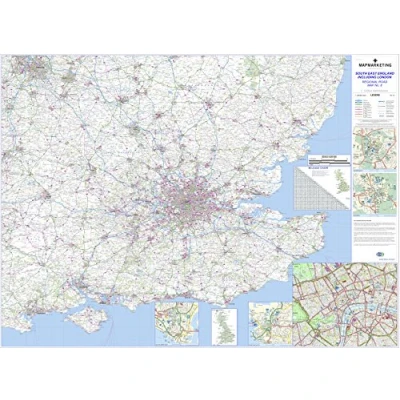
Most roads are shown with motorways, trunk roads, dual carriageways, main and secondary routes all prominently depicted in an easy to read style. A helpful mileage guide is included along with city center street plans for the major cities on each map. Ideal for regional route planning, these maps also feature helpful information such as railways, airports, county boundaries and rivers. This map covers the following area - North = Hinckley, South = Swanage, East = Lowestoft, West = Gloucester and has detailed city plans for London, Cambridge, Oxford, Portsmouth, Southampton This large wall map measures 96cm X 130cm ( 38 X 51 Inches ) and is updated annually using the latest mapping data from Collins Bartholomew This series of regional road maps is published exclusively by Map Marketing. This is one map in an eight-sheet map set covering the whole of Great Britain in considerable detail. This map is permanently bonded between two sheets of tough, flexible, crystal-clear plastic for long lasting protection and you can write on / wipe off Size: 96 x 130 cm (38 x 51 inches) Scale: 1:250 000 (3.94 miles: 1 inch) City Plans: Cardiff, Swansea, Plymouth, Torquay, Exeter, Bristol, Bath, Gloucester Regional Insets: Scilly Isles, Channel Islands


Compare webshops (1)
Most roads are shown with motorways, trunk roads, dual carriageways, main and secondary routes all prominently depicted in an easy to read style. A helpful mileage guide is included along with city center street plans for the major cities on each map. Ideal for regional route planning, these maps also feature helpful information such as railways, airports, county boundaries and rivers. This map covers the following area - North = Hinckley, South = Swanage, East = Lowestoft, West = Gloucester and has detailed city plans for London, Cambridge, Oxford, Portsmouth, Southampton This large wall map measures 96cm X 130cm ( 38 X 51 Inches ) and is updated annually using the latest mapping data from Collins Bartholomew This series of regional road maps is published exclusively by Map Marketing. This is one map in an eight-sheet map set covering the whole of Great Britain in considerable detail. This map is permanently bonded between two sheets of tough, flexible, crystal-clear plastic for long lasting protection and you can write on / wipe off Size: 96 x 130 cm (38 x 51 inches) Scale: 1:250 000 (3.94 miles: 1 inch) City Plans: Cardiff, Swansea, Plymouth, Torquay, Exeter, Bristol, Bath, Gloucester Regional Insets: Scilly Isles, Channel Islands
 Product specifications
 Price History
 Related products
 To Shop


