Postcode Sector Map 1 Cornwall And Scilly Isles Wall Laminated With Motorway, A' Roads, B' City Plans, Area, District, Sectors… (Laminated)

|
£ 34.95 | To Shop |
 Description
Amazon
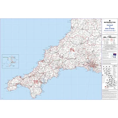
🔎 This Map Features Detailed Information About Motorways, 'A' Roads, 'B' Roads Down To Unclassified Roads, As Well As Area, Sector, District, County And Unitary Authority Boundaries 🗺️ This Map Covers Cornwall And The Isles Of Scilly North- Bradworthy South: The Lizard East: Tavistock West: Land's End 🚩 This Map Shows The First Part Of The Postcode And The First Number Of The Second Part Of The Postcode. This Map Includes All The Postcode Changes From The Most Recent Royal Mail Postcode Update. 🖊️ This Map Is Permanently Bonded Between Two Sheets Of Tough, Flexible, Crystal-clear Plastic, You Can Write On It With Dry Wipes And It Can Be Wiped Off Easily 📐 Map Size:- 73cm X 107cm (29 X 42 Inches). scale- 1:150 000 (2.4 Miles To 1 Inch)


Compare webshops (1)
🔎 This Map Features Detailed Information About Motorways, 'A' Roads, 'B' Roads Down To Unclassified Roads, As Well As Area, Sector, District, County And Unitary Authority Boundaries 🗺️ This Map Covers Cornwall And The Isles Of Scilly North- Bradworthy South: The Lizard East: Tavistock West: Land's End 🚩 This Map Shows The First Part Of The Postcode And The First Number Of The Second Part Of The Postcode. This Map Includes All The Postcode Changes From The Most Recent Royal Mail Postcode Update. 🖊️ This Map Is Permanently Bonded Between Two Sheets Of Tough, Flexible, Crystal-clear Plastic, You Can Write On It With Dry Wipes And It Can Be Wiped Off Easily 📐 Map Size:- 73cm X 107cm (29 X 42 Inches). scale- 1:150 000 (2.4 Miles To 1 Inch)
 Product specifications
 Price History
 Related products
 To Shop


