South West Wales Postcode Sector Map 10 Wall With Motorway, A' Roads, B' City Plans, Area, District, SectorsSize: 73 x 107 cm (29 42 inches) Scale: 1:150 000 (2.4 miles to 1 inch)

|
£ 24.99 | To Shop |
 Description
Amazon
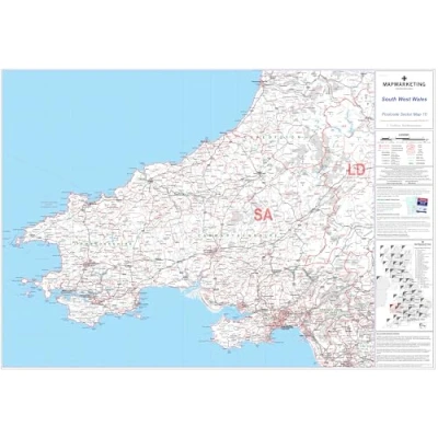
Sector Sheet 10 specifically covers South West Wales, offering detailed insight into postal sectors within the region. The map measures 73 x 107 cm (29 x 42 inches), providing ample space for clear visualization of geographic features and postal sectors. Scaled at 1:150,000, with 2.4 miles corresponding to 1 inch on the map, allowing for accurate measurement of distances and easy interpretation of geographic features. Geographical coverage guide includes key landmarks such as Aberystwyth to the north, Port Talbot to the south, Treorchy to the east, and St David's Head to the west, aiding users in understanding the map's scope and assisting with orientation. Updated with the latest Royal Mail Postcode Update R54 (March 2012), the map displays area, district, and sector boundaries and identifiers in red, with County and Unitary Authority boundaries presented in green, ensuring users have access to the most up-to-date postal information.


Compare webshops (1)
Sector Sheet 10 specifically covers South West Wales, offering detailed insight into postal sectors within the region. The map measures 73 x 107 cm (29 x 42 inches), providing ample space for clear visualization of geographic features and postal sectors. Scaled at 1:150,000, with 2.4 miles corresponding to 1 inch on the map, allowing for accurate measurement of distances and easy interpretation of geographic features. Geographical coverage guide includes key landmarks such as Aberystwyth to the north, Port Talbot to the south, Treorchy to the east, and St David's Head to the west, aiding users in understanding the map's scope and assisting with orientation. Updated with the latest Royal Mail Postcode Update R54 (March 2012), the map displays area, district, and sector boundaries and identifiers in red, with County and Unitary Authority boundaries presented in green, ensuring users have access to the most up-to-date postal information.
 Product specifications
 Price History
 Related products
 To Shop


