UK Postcode Wall Map Laminated Large Clearly Shows Postcode, County And District Boundaries, Main Roads, Cities, Towns Villages 120cm X 83cm (Laminated)
Prices from
COMPARE ALL WEBSHOPS
(1)
Amazon
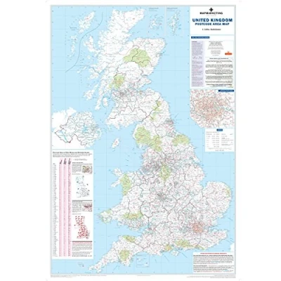
🗺️ Clear Postcode Boundaries – Shows all 124 UK Postcode Areas in red with County & Unitary Authority lines in dark green for easy reference. 📍 Detailed London Inset – Includes a focused map of the Greater London area (M25) to help with dense postcode navigation. 📚 Helpful Index & Key – Handy reference list includes all Postcode Areas and their main towns or cities—easy to search and find fast! 🚛 Great for Business Use – Ideal for planning sales territories, delivery zones, or service areas with road and population data included. 🔄 Updated Annually – Reprinted each year to ensure boundary accuracy and the most up-to-date postcode and administrative data.
Read more
29.99

|
£ 29.99 | To Shop |
 Description
Amazon
🗺️ Clear Postcode Boundaries – Shows all 124 UK Postcode Areas in red with County & Unitary Authority lines in dark green for easy reference. 📍 Detailed London Inset – Includes a focused map of the Greater London area (M25) to help with dense postcode navigation. 📚 Helpful Index & Key – Handy reference list includes all Postcode Areas and their main towns or cities—easy to search and find fast! 🚛 Great for Business Use – Ideal for planning sales territories, delivery zones, or service areas with road and population data included. 🔄 Updated Annually – Reprinted each year to ensure boundary accuracy and the most up-to-date postcode and administrative data.


Compare webshops (1)
Shop

Price
🗺️ Clear Postcode Boundaries – Shows all 124 UK Postcode Areas in red with County & Unitary Authority lines in dark green for easy reference. 📍 Detailed London Inset – Includes a focused map of the Greater London area (M25) to help with dense postcode navigation. 📚 Helpful Index & Key – Handy reference list includes all Postcode Areas and their main towns or cities—easy to search and find fast! 🚛 Great for Business Use – Ideal for planning sales territories, delivery zones, or service areas with road and population data included. 🔄 Updated Annually – Reprinted each year to ensure boundary accuracy and the most up-to-date postcode and administrative data.
 Product specifications
 Price History
 Related products
 To Shop


