UK Roads Wall Map Laminated Large Size: 120 x 174 cm Clearly Shows Motorways, A Roads, B Minor Postcode Areas, London Inset With M25

|
£ 99.99 | To Shop |
 Description
Amazon
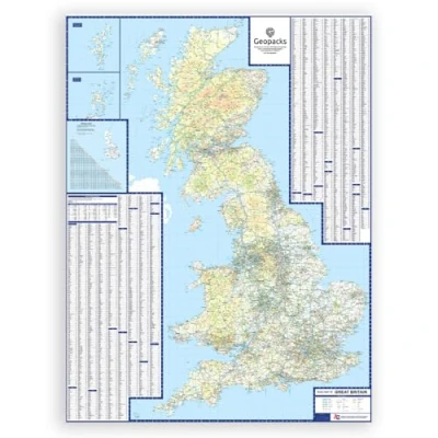
Full UK Coverage – Explore all of Great Britain, including England, Scotland, Wales & islands, with detailed roads, cities, rivers, and landmarks. Highly Detailed – Includes motorways, A-roads, railways, elevation shading, and topographic detail for clear and accurate navigation. Inset Maps for Clarity – Features enlarged sections of busy regions to make high-traffic areas easy to read and plan around. Easy to Use – Grid references and clearly labelled points of interest make it perfect for travel planning, education, or daily use. Premium Quality Print – Printed on durable, high-quality paper for long-term use in the car, classroom, or home. Specifications: 15.24 Miles to 1 inch/ 9.6km to 1cm


Compare webshops (1)
Full UK Coverage – Explore all of Great Britain, including England, Scotland, Wales & islands, with detailed roads, cities, rivers, and landmarks. Highly Detailed – Includes motorways, A-roads, railways, elevation shading, and topographic detail for clear and accurate navigation. Inset Maps for Clarity – Features enlarged sections of busy regions to make high-traffic areas easy to read and plan around. Easy to Use – Grid references and clearly labelled points of interest make it perfect for travel planning, education, or daily use. Premium Quality Print – Printed on durable, high-quality paper for long-term use in the car, classroom, or home. Specifications: 15.24 Miles to 1 inch/ 9.6km to 1cm
 Product specifications
 Price History
Prices were last updated on:
 Related products
 To Shop


