UK Wall Map Laminated Large Counties, District and Unitary Authority Boundaries Local Councils, Roadmap, Postcode Areas, London Boroughs, Population Figures

|
£ 29.99 | To Shop |
 Description
Amazon
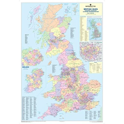
Detailed - This map shows County, District and Unitary Authority boundaries within the United Kingdom, The divisions of each County into its local District Council areas are clearly shown. Roadmap - The map shows motorways and primary roads and features town and city stamps based on population including inhabitants. Postcoded - Inset is a smaller map showing the full postcode boundaries within the UK and listing areas giving their main postal towns. The inset map of London outlines the Boroughs information. Up to date - The recently published 2019 edition of the Counties map reflects the administrative changes that came into effect in April 2009. Durable - This map is permanently bonded between two sheets of tough, flexible, crystal-clear plastic. This finish allows you to write on, wipe off with dry or wet wipe pens. Size: 120 x 83 cm


Compare webshops (1)
Detailed - This map shows County, District and Unitary Authority boundaries within the United Kingdom, The divisions of each County into its local District Council areas are clearly shown. Roadmap - The map shows motorways and primary roads and features town and city stamps based on population including inhabitants. Postcoded - Inset is a smaller map showing the full postcode boundaries within the UK and listing areas giving their main postal towns. The inset map of London outlines the Boroughs information. Up to date - The recently published 2019 edition of the Counties map reflects the administrative changes that came into effect in April 2009. Durable - This map is permanently bonded between two sheets of tough, flexible, crystal-clear plastic. This finish allows you to write on, wipe off with dry or wet wipe pens. Size: 120 x 83 cm
 Product specifications
 Price History
 Related products
 To Shop


