Glasgow and the Clyde Postcode Sector Map 25 Wall With Motorway, A' Roads, B' City Plans, Area, District, Size: 73 x 107 cm (29 42 inches) Scale: 1:150 000 (2.4 miles to 1 inch)

|
£ 19.99 | To Shop |
 Description
Amazon
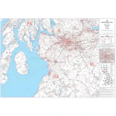
Sector Sheet 25 - Comprehensive Coverage: This map sheet offers detailed coverage of Glasgow & the Clyde region's postal sectors, aiding in navigation and location identification within the area. Dimensions and Scale: With dimensions of 73 x 107 cm (29 x 42 inches) and a scale of 1:150,000 (2.4 miles to 1 inch), the map provides a balance between detail and readability, making it suitable for various uses. Geographical Coverage Guide: Highlighting key geographical points such as Aberfoyle to the north, Carronbridge to the south, Carnwath to the east, and Kilberry to the west, the guide assists users in orienting themselves within the region. Updated Postal Information: The map incorporates the latest postal changes from the Royal Mail Postcode Update R54 (March 2012), including area, district, and sector boundaries. County and Unitary Authority boundaries are clearly marked in green for easy reference. Base Map Features: In addition to postal sector information, the map base includes essential features such as motorways, primary, 'A', and unclassified roads. Conurbation shapes and city plan insets provide detailed street-level information for major cities, enhancing the map's utility for navigation purposes.


Compare webshops (1)
Sector Sheet 25 - Comprehensive Coverage: This map sheet offers detailed coverage of Glasgow & the Clyde region's postal sectors, aiding in navigation and location identification within the area. Dimensions and Scale: With dimensions of 73 x 107 cm (29 x 42 inches) and a scale of 1:150,000 (2.4 miles to 1 inch), the map provides a balance between detail and readability, making it suitable for various uses. Geographical Coverage Guide: Highlighting key geographical points such as Aberfoyle to the north, Carronbridge to the south, Carnwath to the east, and Kilberry to the west, the guide assists users in orienting themselves within the region. Updated Postal Information: The map incorporates the latest postal changes from the Royal Mail Postcode Update R54 (March 2012), including area, district, and sector boundaries. County and Unitary Authority boundaries are clearly marked in green for easy reference. Base Map Features: In addition to postal sector information, the map base includes essential features such as motorways, primary, 'A', and unclassified roads. Conurbation shapes and city plan insets provide detailed street-level information for major cities, enhancing the map's utility for navigation purposes.
 Product specifications
 Price History
 Related products
 To Shop


