Yorkshire & East Riding LEEDS/BRADFORD Postcode Sector Map 20 Wall With Motorway, A' Roads, B' City Plans, Area, District, Sectors Size: 73 x 107 cm Scale: 1:150,000 Laminated

|
£ 34.95 | To Shop |
 Description
Amazon
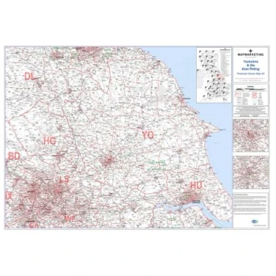
Sector Sheet 20 offers a comprehensive postcode sector map covering Yorkshire and the East Riding, providing detailed geographic information essential for navigation and planning in the region. With dimensions of 73 x 107 cm (29 x 42 inches), this map provides ample space for clear visualization and detailed examination of the area, facilitating effective decision-making and route planning. The scale of 1:150,000 (1 inch to 2.4 miles) ensures accuracy and precision in representing geographical features and locations, allowing users to navigate with confidence. Geographically, the map spans from Stockton-on-Tees in the north to Thorne in the south, and from Bridlington in the east to Halifax in the west, covering key landmarks and areas within Yorkshire and the East Riding. Updated with the latest data from the Royal Mail Postcode Update, this sector map reflects all recent postcode changes, ensuring relevance and accuracy for users. Additionally, area, district, and sector boundaries are clearly delineated in red, while county and unitary authority boundaries are highlighted in green, providing a comprehensive understanding of administrative divisions.


Compare webshops (1)
Sector Sheet 20 offers a comprehensive postcode sector map covering Yorkshire and the East Riding, providing detailed geographic information essential for navigation and planning in the region. With dimensions of 73 x 107 cm (29 x 42 inches), this map provides ample space for clear visualization and detailed examination of the area, facilitating effective decision-making and route planning. The scale of 1:150,000 (1 inch to 2.4 miles) ensures accuracy and precision in representing geographical features and locations, allowing users to navigate with confidence. Geographically, the map spans from Stockton-on-Tees in the north to Thorne in the south, and from Bridlington in the east to Halifax in the west, covering key landmarks and areas within Yorkshire and the East Riding. Updated with the latest data from the Royal Mail Postcode Update, this sector map reflects all recent postcode changes, ensuring relevance and accuracy for users. Additionally, area, district, and sector boundaries are clearly delineated in red, while county and unitary authority boundaries are highlighted in green, providing a comprehensive understanding of administrative divisions.
 Product specifications
 Price History
Prices were last updated on:
 Related products
 To Shop


